Saturday, May 31, 2014

Halifax - Day 3 Nova Scotia

It's Saturday and a day of rest for us.  We're back at the RV in Muncton after three days in Nova Scotia. Laundry and relaxing are the day's agenda.

On Friday, we drove into Halifax in the morning and visited the Halifax Citadel there, a very interesting military national historic site on a hill above the city and bay. The first fort was build on this hill in 1749 and the fourth and current fortress was built as a result of the War of 1812. The French and the British were not the best of friends when it came to claiming territories in this end of Canada. The strategic location played a part in the British Navy even until 1906, and then with the Canadian military through World Wars I and II.  Very interesting.  And the fortress certainly looks impenetrable. Some pictures to follow:
View of the city as we walked up the hill to the gate of the Citadel 

Guard at the gate

Bob at the door

Practicing shooting of the cannon.  The masts are part of the fort and were used
for communication with ships in the bay and the people of Halifax
These kilted lads were practicing on the grounds for some of their live demonstrations
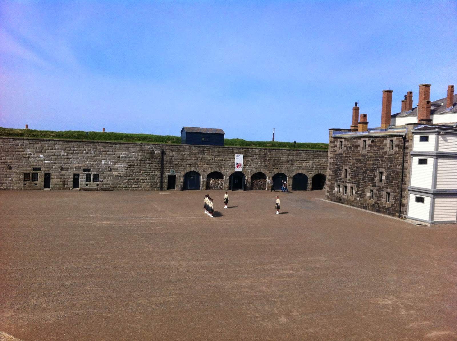
Another view of them with a general sense of the inside of the fort
Linda with cannon - notice track so they could aim in several directions through the grassy rampart
One view of the city through an opening in the rampart
Walking back down the hill, I got a good shot of the Old Town Clock tower, built in 1800. Prince Edward, Duke of Kent and commander-in-chief of all military forces in British North America, had the four sided clock built to resolve the tardiness of the local garrison.
Old Town Clock

Then we drove down to the water front and walked around on a beautiful day and enjoyed the wharf.
Linda on the boardwalk with the Tall Ship Silva in the background, used for local sails

The Acadia was "on display" and described as the largest artifact in the Atlantic Maritime Museum that is there on the water front.  She's a museum ship, "one of the best preserved Edwardian ocean steamships in the world." She specialized in the charting of the coastline of Eastern Canada from 1913-1969.


This is a picture of the Old Town Clock up on the grounds of the Citadel looking up from the water front.
Old Town Clock up the hill

After Halifax we drove to Peggy's Cove.  It's a barren rock (granite) community on the edge of St. Margaret's Bay and the Atlantic Ocean.  We had lunch there and Bob had his first lobster.
Peggy's Cove Light House

Looking back at the village. Our place mats said population of 35, year round

Some carvings by an art studio
Bob gets instructions from the waitress for eating his crab

That's hard work
Perhaps you can sense that we had a very busy day.  We drove back to Muncton to rest up for our last day in the Maritimes on Prince Edward's Island.


Thursday, May 29, 2014

Cabot Trail - Day 2 in Nova Scotia

The day started out with a plan to drive around Cape Breton Island, which includes the Cape Breton Highlands National Park and the Cabot Trail, which completely encircles the northern most parts of Nova Scotia.
Our starting  spot for the Cabot Trail
We had a good omen for the day.  We saw an eagle take off from a tree.
Can you see the eagle on the top of the conifer?


A shot of him flying away

There were many beautiful views of the coastline.


And there were many fishing boats out setting traps, probably for lobster or crabs.
Bob counted 15 boats in this one area

This side of the island is heavily influenced but it's Scottish heritage and traditions.  They teach Gaelic in the schools and all of the road signs were in both languages.  Never thought we'd need to know Gaelic for this trip.
A little Gaelic lesson
While in the Highlands we saw our first and only moose, even though we'd been seeing warning signs all the while we've been in the Maritime Provinces. She was grazing on some tidbits by the side of the road.  There was still patches of snow everywhere.  She must have found something green in the ditch.  Bob called to her and she looked up to see who was calling, completely unconcerned with us.
Lady moose out for lunch
An interesting stop was for a "Lone Sheiling," again reflecting the Scottish Heritage of this area. It's a sample of dwelling built by the shepherds who would be tending sheep in the Highlands of Scotland.  It was built in 1942 to recognize the similarities between this land and Scotland.
Lone Sheiling, room for the shepherd and some of his animals

We continued on to the west side of the island (which feels a lot like a peninsula), where the coast line and continuing road looked like this. Had lunch in Cheticamp, where the landmarks reflect the Acadian (French) influence on this side of the island.
West Coast view on a beautiful, sunny day for a drive


Wednesday, May 28, 2014

Day 1 - Nova Scotia

Baddeck NS was our destination today.  We had made reservations at a B & B for tonight. On the way we stopped and did some wine tasting at the Jost winery, the oldest and largest winery in Nova Scotia. It was a great way to start our day, with a before 10am tasting and some purchases.

When we arrived in Baddeck, we spent some time touring the Alexander Graham Bell Museum. Baddeck was his summer home and a location from which he conducted many experiments in flight, hydrofoiles, kites, and a variety of other things. He was interested in many things beyond the telephone and this location was a favorite of his family's.
The Bell Museum looking out to the Bras d'Or Lake,
an inland sea where Baddeck sits. Please notice the sun is shining and it's a little warm.
Me standing outside the museum next to a blooming magnolia.  They're having
a really late spring (as are many places) and the daffodils are at their peak.
This is the Kidston Island light house that sits right across from the waterfront in Baddeck.
You can see it just over my shoulder in the picture above.

Tuesday, May 27, 2014

Fundy National Park and Lunch at Alma

Today was a busy day of visiting interesting sights in the Fundy National Park on the north side of the Bay of Fundy in New Brunswick. We started in Alma, NB on the edge of the park and decided to return there for a late lunch.  The first two pictures show the difference in the tide over just about three hours. The one on the left is at high tide and the one on the right is when we came back for lunch about mid-tide.
Boats floating in harbor


Boats about 3 1/2 hours later, sitting on the bottom at mid-tide


On our way to Point Wolfe we saw this covered bridge.  Then we took a hike down to the beach.
Sawmill Creek Bridge 1905

We saw this little falls on the trail down, including some down hill trail and a set of steps at the end.

We saw kayaks out on the bay, even though it was very cold.  It's a very popular sport around here.


This is the set of steps we took to get back up to the parking lot. Yes, that's Linda and she made it all the way up.

Another walk was in a high (1200 ft. elevation) part of the park - Caribou Plain.  Caribou once roamed there but are no longer in the area.

More hiking on a boardwalk through the Caribou Plain
When all was done, we return to Alma, NB for a lovely lunch. The tide had fallen considerably, even though it wasn't low tide for another couple of hours.
Alma is in the background, looking from the beach

Hopewell Rocks

We ventured out in the rain and cold from our "campground" (It's really an RV park). We drove around Moncton and on to the closest attraction on the Bay of Fundy.  The tides expose rocks at low tide that stand stories above your head while you walk on the ocean floor. At high tide only the tops of the rocks show and they look like islands.  We walked down to the beach and talked to the ranger who was dressed in his summer shorts, even though it was about 42 degrees and really cold in the wind. He took our picture.
Bob and Linda at Hopewell Rocks, about mid-tide
The ranger estimated that the tide would reach about 41 feet on this particular day, the difference between high and low tides.

Looking down to some of the rocks
Can you see the ranger in his shorts? It was a hike down and then, of course, a hike back up.

The Bay of Fundy as seen from our lunch spot.
The bay is this chocolate brown color because of the always moving tides

At about mid-tide, the mud flats are starting to be exposed


Sunday, May 25, 2014

Arrival in Moncton, NB

We're finally at our destination.  Eight days scheduled at this campground to make day trips all over the Atlantic Provinces.  :)

One Night in Quebec and another in St. Jacques, NB

We drove out of Ontario and into Quebec. We had been warned that all the road signs were only in French. It didn’t cause too much trouble. We just followed the numbers (same in both languages.) The campground brochure was in French and we had to use sign language to find out where the trash dumpsters were. Over-air television was plentiful since we were just outside of Montreal, but 5-6 stations out of the nine we could get were in French.

We had a first on Friday, though.  We crossed the St. Lawrence River, a huge water way that gets bigger and bigger the farther northeast that you go.


We followed the south side of the river after Quebec City and decided to take a closer look at the local neighborhoods. We left the freeway and drove into this little town on the river. I don’t remember it’s name but it was probably St. Something, as many of the Quebec cities are named after Saints.  Many of them sport a church with similar steeples to the ones in the picture. Beautiful little river towns just waiting for the summer tourist season to begin.

 You can see the St. Lawrence in the background of this picture as we approached the town.  It’s the brown water on the right of the picture.


As we traveled through Quebec, we found most people to be bilingual and ordering a sandwich at Subway was easier than we thought it was going to be when we heard the customers ahead of us ordering in French. We found this sign at the campground office when we checked in. (now in New Brunswick but still very French.)  The address this night is really St, Jacques, NB for all of those who care.  For the others reading this blog, that is my mother's maiden name and the last name of many of my relatives.
Sounds like an invitation for a beer.

We've had another first - we're in the Atlantic Time Zone, four hours different from Home. Sunrise and sunset are early and late, making for long days this far north.

125 years for the Port Huron Church

Sorry about the tardiness of this post.  I found this post from last Sunday and it was never made public.  For this last week we've had spotty internet connections so today I'm also posting last night's ramblings and a comment for tonight.

Sunday, May 18, 2014
Today's celebration was a great event.  Church went on for an hour and 40 minutes, but nobody minded. We had lunch at the country club and got to do lots more visiting.
First Presbyterian has been standing on the same corner for many years
Later in the day we went down to look at the St. Claire River and the Lake again.  The ships were all gone from the bottom of Lake Huron.
View of South Lake Huron with Canada across the river
The campground has been interesting. This is the weekend that Canadians celebrate Victoria Day. Many have been at the campground, enjoying their long weekend.  This next picture is of the Blue Water Bridge over the St. Claire River, into Sarnia, Ontario. Can you see the line of cars (little bumps on the far span) going east, ending their weekend of camping or shopping or whatever a little early. Many of the businesses were have Canadian appreciation specials. Half of the license plates around town were from Ontario.
Blue Water Bridge to Sarnia